
Introduction of Inclinometer:
In geotechnical and structural engineering, inclinometer testing—also referred to as slope inclinometry or in-place inclinometer monitoring—is a crucial method for determining the lateral displacement of the earth. This technique tracks horizontal ground movement over time using inclinometer probes that are placed into pre-installed casing inside boreholes. When evaluating the stability of slopes, embankments, retaining walls, deep excavations, tunnels, and dams, it is especially useful. In order to ensure the safety and functionality of civil infrastructure, inclinometer testing gives engineers the ability to precisely determine subsurface movement profiles, validate design assumptions, and comprehend failure mechanisms.
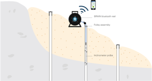
The inclinometer test is to measure the probe’s tilt or angle of deviation from vertical. A displacement-versus-depth profile can be created by taking successive measurements along the borehole’s length. This profile can then be examined over time to identify patterns in ground movement. Manual or automatic inclinometer systems can be used for continuous or periodic monitoring, depending on the needs of the project.
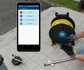
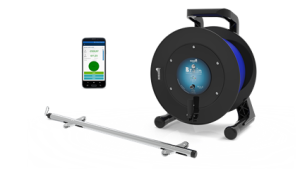 Nowadays, the majority of geotechnical firms use advanced inclinometers, particularly the B.R.A.IN inclinometer. The B.R.A.I.N. Inclinometer system is perfect for long-term monitoring projects because it also has a strong data acquisition unit that can log and transmit data remotely in real-time or on a schedule. Engineers around the world rely on the BRAIN inclinometer for crucial geotechnical applications like landslide warning systems, tunnel convergence monitoring, and deformation analysis in soft ground conditions because of its integrated diagnostics, corrosion-resistant materials, and smooth integration with data visualization platforms. Because of its versatility and sophisticated automation, it is especially well-suited for demanding settings where manual readings might be dangerous or impractical.
Market Size and Growth:
Global Market Overview:
The growing need for real-time ground movement monitoring in mining, infrastructure, and urban development projects is driving the steady growth of the global market for geotechnical and structural health monitoring, including inclinometer testing. The use of inclinometers has become a crucial component of ground stability assessment and preventive geotechnical engineering due to increased awareness of disaster risk reduction and the necessity of early-warning systems in areas that are prone to landslides or earthquakes.
Because of their specialized function in lateral displacement detection, inclinometer systems account for a sizeable portion of the global geotechnical instrumentation and monitoring market, which was valued at over USD 4 billion as of 2023. According to market analysts, this sector is expected to grow at a compound annual growth rate (CAGR) of approximately 6–8%, surpassing USD 6.5 billion by 2030. This trend is anticipated to continue due to a strong push from government regulations, extensive infrastructure projects, and the incorporation of smart monitoring technologies.
Key Growth Drivers Worldwide:
- Demand for Continuous and Remote Monitoring
The need for inclinometer systems, particularly automated ones, is growing as long-term performance monitoring of vital infrastructure, including dams, tunnels, bridges, and retaining walls, becomes more and more important.
- Integration with Smart Data Platforms
In keeping with Industry 4.0 trends in civil engineering, contemporary inclinometers, such as B.R.A.I.N. Inclinometer system, are now Internet of Things (IoT) enabled and compatible with web-based platforms for real-time data analytics.
 Rise in Urban Infrastructure and Megaprojects
Ground monitoring is essential for risk mitigation in the massive construction projects that have resulted from the rapid urbanization of emerging economies, especially in Asia-Pacific, the Middle East, and parts of Africa.
- Climate Resilience and Landslide Monitoring
The increasing frequency of climate-induced disasters such as landslides, floods, and ground subsidence has led authorities to mandate geotechnical monitoring in vulnerable zones.
- Innovation in Sensor Technology
The adoption of MEMS-based inclinometer sensors, offering higher accuracy and digital connectivity, is transforming traditional soil monitoring methods into more reliable and scalable systems
Bangladesh Market Perspective:
The use of inclinometer testing is steadily increasing in Bangladesh in tandem with the nation’s developing infrastructure industry. The need for trustworthy subsurface monitoring equipment is growing as a result of the increased emphasis on safety in projects like bridges, metro rail, tunnels, and river protection projects.
Although they are still in their infancy, inclinometer applications are being used by:
- Teams building bridges and flyovers.
- Subterranean excavation projects and metro rail.
- Authorities in charge of protecting embankments and riverbanks.
- Monitoring organizations for slopes and landslides.
- Sites for heavy infrastructure and power plants.
Local demand drivers include:
- Rising construction of high-rise buildings, bridges, and infrastructure. So increased inclinometer test for better foundation design.
- Quality assurance mandates in public projects (HBRI, LGED, RHD, PWD, BBA, RAJUK, COUK, City corporation, Port etc.).
- Increasing awareness of international testing standards (ISO, ASTM, DIN).
Role of ICONIC ENGINEERING LTD in Inclinometer Testing:
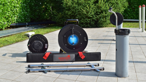
Iconic Engineering Ltd. is a technical distributor and geotechnical service provider in Bangladesh that offers cutting-edge inclinometer solutions from international producers such as Sisgeo Srl. The business provides installation, data collection, training, and ongoing monitoring support to engineers and project teams.
Key Contributions Include:
- One of the main contributions is the importation and distribution of genuine inclinometer systems, both automatic and manual.
- Holding orientation, training, and field deployment sessions for slope and subsurface monitoring.
- Providing project-specific technical services, data logging, and borehole installation in accordance with international best practices.
Contributing to Digital Bangladesh:
By introducing smart inclinometer systems like B.R.A.I.N. type, which enable real-time data, remote access, and automated analysis, Iconic Engineering Ltd. is advancing digital geotechnical monitoring. This supports the goal of Digital Bangladesh by:
- Digital Monitoring: Using cloud platforms to remotely track ground movement.
- Real-Time Alerts: Immediate access to data for risk assessment and judgment.
- System Integration: Smooth interaction with digital project dashboards and smart infrastructure.
Test Procedure for Inclinometer Testing:
- Setting Up the Site
Geotechnical risk areas are used to choose an appropriate site. Drilling a borehole to the necessary depth usually reaches the anticipated zones of slippage or deformation.
- Inclinometer Casing Installation
Installed vertically in the borehole is a grooved ABS or PVC inclinometer casing. The grooves need to line up with the direction of monitoring, which is typically perpendicular to the structure or downslope.
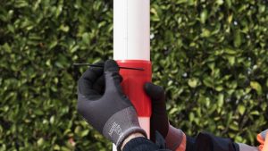
- Backfilling or grouting
To guarantee tight contact with the surrounding soil or rock, grout is used to fill the annular space between the casing and the borehole wall. This enables the deformation of the casing to reflect any lateral movement.
- First Baseline Value
An inclinometer probe (either digital or manual) is used to take a baseline reading after the grout has dried. For all upcoming measurements, this serves as the reference profile.
- Regular Observation
To compare with the baseline, subsequent readings are taken at predetermined intervals (weekly or monthly, for example). To record tilt angles, the inclinometer probe is lowered down the casing and stopped at predetermined depths (usually every 0.5 m).
- Gathering and Downloading Data
Two orthogonal directions of tilt data (A and B) are gathered, recorded, and sent to analysis software for processing.
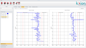
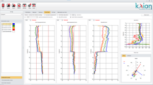
- Data Interpretation and Profile Creation
To evaluate ground behavior over time, displacement and cumulative movement profiles are produced. Lateral ground movement is indicated by any departure from the initial alignment.

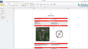
- Interpretation and Reporting
Reports are created that display time-based trends and displacement vs. depth graphs. Engineers can use these insights to inform decisions about structural integrity, slope stability, and mitigation requirements.
Outcome of Inclinometer Testing:
Accurate, non-destructive information about lateral ground movement over time is provided by inclinometer testing. In regions where structural stability is an issue, it is essential for tracking the displacement of rock and soil. Typical results include:
- Displacement profiles showing different depths of horizontal soil movement.
- Early identification of ground instability or slope failure.
- Performance assessment of deep excavations, embankments, and retaining walls.
- Assistance with risk mitigation planning and the validation of geotechnical designs.
Advantages of Inclinometer Testing:
- Accurately identifying lateral soil or rock movement; non-destructive and safe for long-term ground condition monitoring.
- Field-friendly and portable, it can be used in difficult-to-reach places.
- Provides flexible data collection by supporting both automated and manual Inclinometer systems.
- Suitable for a variety of geotechnical situations, such as slopes, tunnels, and deep foundations;
- Allows for prompt reaction to ground deformation through real-time monitoring.
Future Scope of Inclinometer Testing:
- AI-Based Analysis: Early warning systems will be automated and movement trends will be better detected thanks to machine learning.
- Integration with BIM and GIS Platforms: synchronization of real-time data with construction modeling and geospatial tools.
- Improved Durability: For harsh field conditions, inclinometer systems of the future will have more resilient, corrosion-resistant designs.
- Increased remote, cloud-based monitoring with less manual involvement thanks to wireless and Internet of Things connectivity.
Conclusion:
Inclinometer testing provides precise, non-destructive measurement of lateral ground movement, it is essential to contemporary geotechnical monitoring. It provides vital information that supports safe design and prompt intervention and is frequently used to evaluate the stability of slopes, embankments, tunnels, and deep excavations. It is essential for both short-term investigations and long-term infrastructure monitoring due to its versatility in handling a variety of site conditions, the increasing integration of digital systems, and real-time data acquisition. As technology develops, inclinometer systems are getting smarter, more robust, and more compatible with civil engineering predictive risk management techniques.